EU to Use Satellites to Track Climate-Induced Wildfires and Illegal Logging in Forests
3 min read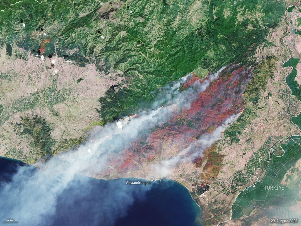
A Copernicus Sentinel-2 satellite image shows a wildfire near Alexandroupoli in the Evros region of northeast Greece on Aug. 23, 2023. European Space Agency
 Why you can trust us
Founded in 2005 as an Ohio-based environmental newspaper, EcoWatch is a digital platform dedicated to publishing quality, science-based content on environmental issues, causes, and solutions.
The European Commission and the European Space Agency (ESA) have partnered to use satellites to address climate crisis threats and illegal logging in European Union (EU) forests.
The commission has proposed a new law where the EU would use Copernicus Sentinel satellites to collect forest data in order to stay on top of threats like logging and wildfires exacerbated by climate change, reported Reuters.
“As world leaders grapple with the urgency of climate action, the role of space-based technology and data has become increasingly critical,” a press release from the ESA said. “Access to actionable information is fundamental to fight climate change, to support knowledge-based policies and initiatives and their implementation, and to ensure that this is balanced with sustainable economic development and societal benefits.”
EU member countries would also be required to measure on-the-ground trends, including the volume of trees and ancient forest locations.
“We need to see the trends, need to predict better, we need to see how they are responding to climate change,” Virginijus Sinkevicius, EU Environment Commissioner, told Reuters. “At this moment there are no comprehensive monitoring requirements to provide an overall picture of the state of our forests.”
According to Brussels, data provided by EU member states currently has long delays and gaps, which get in the way of the ability to prepare for climate threats.
Extreme heat and drought in the EU have increased the risk of destructive wildfires. More than two million acres was lost to forest fires last year, according to government data, Reuters reported.
Sinkevicius said the new satellite data will help keep track of illegal logging and other threats across borders.
Europe’s forests are essential for storing carbon dioxide and helping to meet nations’ climate goals, as well as for flood protection.
Last year, 43 percent of land affected by wildfires in Europe was in the network of Natura 2000 protected areas, which cover many habitats and threatened species, reported Euronews Green.
EU forest protection group Fern said the new law was “a potentially golden opportunity,” but added that it should also require EU nations to take steps to boost the health of forests, Reuters reported.
“Space, and in particular Earth observation, offers a unique perspective on how to tackle climate challenges faced by humanity,” said Kurt Vandenberghe, the European Commission’s director-general for climate action, in the press release. “Space technologies are crucial for reaching climate neutrality and climate resilience by 2050. Through our joint initiative, we are committed to exploring and enhancing opportunities for the development and broader implementation of space-based solutions dedicated to climate action.”
Subscribe to get exclusive updates in our daily newsletter!
By signing up, you agree to the Terms of Use and Privacy Policy & to receive electronic communications from EcoWatch Media Group, which may include marketing promotions, advertisements and sponsored content.