Annual GMSAT predictions and ENSO
3 min read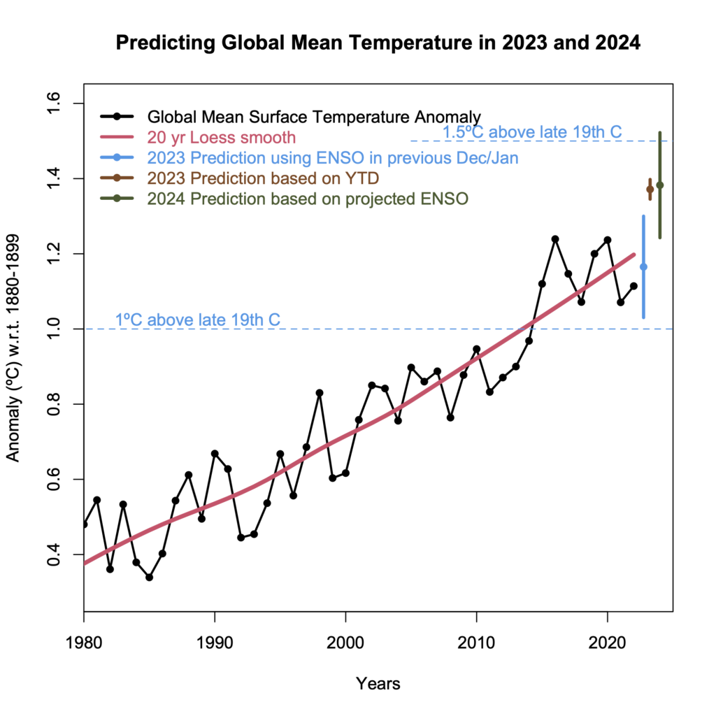
For the last few years (since at least 2016), I’ve shared predictions for the next annual global mean surface air temperature (GMSAT) anomaly based on the long term trend and the state of ENSO at the start of the year. Generally speaking, this has been quite skillful compared to persistence or just the long term trend alone – the eventual anomaly was consistently within the predicted bounds. Until 2023.
As described in my original post on 538, I take a loess smooth for the GISTEMP long term trend (using roughly 20 year smoothing) and add a term based on the linear regression of the beginning of the year Multivariate ENSO Index (MEI2) (similar to Nino34) to the detrended anomalies (not including some big volcanic years). This makes sense since, historically, the interannual variations in GMSAT were largest in the first half of the year and dominated by the phase of ENSO (El Niño or La Niña). This pattern was important for recent record or near-record years like 2016 or 2020 which started with El Niño, as well as below-trend years like 2017, 2021 etc. that started with La Niña. The development of the ENSO phase in the latter part of the year (which peaks around December/January) generally has less of an impact because of the lag of ~3 months or so of its affect on global temperatures.
There are two main sources of uncertainty in this method, the variation of temperature not related to the prior ENSO, and the uncertainty in the DJF ENSO index from the Dec predictions. Thus the true prediction (made around Jan 1), is slightly more uncertain than the retrodiction (which knows the actual DJF ENSO value). As mentioned above, this technique has historically been quite skillful:
The RMS forecast error (not including 2023), is 0.07ºC, compared to 0.10ºC for persistence or smoothed trends. This year however was noticeably warmer than the prediction or retrodiction based only on DJF ENSO at the beginning of the year (which you will recall was a slight La Niña), falling well above the 95% CI.
This could be due to a real anomaly in the interannual variability that was outside the 95% expectation, a mis-specification in the statistical model (e.g. we could have included an autumnal ENSO state as an additional predictor, or taken predicted forcings (solar, aerosols, volcanoes) into account), or something extra that we just haven’t seen before.
But how are we going to find out? What happens in 2024 will be important. Does it go back to being predictable based on ENSO (in which case 2024 is expected to just be a little warmer than 2023), or does the positive anomaly persist? We will also be seeing more comprehensive estimates of the impact of the Hunga-Tonga eruption, and also of the impacts of the decreases in marine shipping emissions. It might be that the initial estimates of their impacts were underestimated. We will also see more in depth explorations of the spring to fall anomalies in the North Atlantic/North Pacific which contributed strongly to the temperature changes, but aren’t obviously related to El Niño.
If nothing else, 2023 reminds us that the climate system still has surprises for us, and that this would be a very bad time to our eyes off the ball.